1. Land degradation is generally defined as declining conditions of soil and water resources and the loss of biodiversity; agriculture is understood to be the primary driver globally.
2. The share of U.S lands degraded is obscured due to limited national assessments, a lack of clarity from federal agencies, and a cultural tendency to support grazing rights and practices.
3. About half of U.S. contiguous land is used for agriculture; much of that land is undergoing losses in soil and water resources and biodiversity, i.e., land degradation.
4. At least 20% of contiguous total U.S. land is degraded; animal agriculture is almost certainly the primary driver.
5. Very broadly estimated, it is likely that at least a third of grazing lands and about a third of croplands are degraded; monoculture feed crops are likely responsible for the highest levels of cropland degradation.
In international usage, the term land degradation has varying definitions, though all include:
![]() Declines in biodiversity (plants and animals).
Declines in biodiversity (plants and animals).![]() Diminishing quality of soils, including their loss due to erosion or decreases in soil organic matter.
Diminishing quality of soils, including their loss due to erosion or decreases in soil organic matter. ![]() Decreasing ability of the land to hold or manage water supply.
Decreasing ability of the land to hold or manage water supply.
See, Global Land Degradation and Agriculture [question: “How is land degradation defined?”]
![]() Lack of usage and definition – The term “degradation” is rarely used by U.S. federal agencies. A variety of alternate (and more ambiguous) terms are used.[1,2] Land degradation is inherently difficult to define and measure.[3]
Lack of usage and definition – The term “degradation” is rarely used by U.S. federal agencies. A variety of alternate (and more ambiguous) terms are used.[1,2] Land degradation is inherently difficult to define and measure.[3]
![]() Lack of national assessments – We are not aware of any federal efforts to assess land degradation on a national scale, nor any agency mandate for national assessment.[4] The USDA assesses agricultural land, which is by far the largest land use and most prone to degradation. However, the agency steadfastly avoids broad evaluations that might clarify national levels of degradation. Researchers have noted a “literature gap,” especially for the vast amounts of land used for grazing.[5]
Lack of national assessments – We are not aware of any federal efforts to assess land degradation on a national scale, nor any agency mandate for national assessment.[4] The USDA assesses agricultural land, which is by far the largest land use and most prone to degradation. However, the agency steadfastly avoids broad evaluations that might clarify national levels of degradation. Researchers have noted a “literature gap,” especially for the vast amounts of land used for grazing.[5]
![]() Assessments are challenging – Given the inherent complexity of measuring land degradation, the overlapping and ill-defined environmental responsibilities of government agencies (USDA, USGS, EPA, USFWS), and the wide range of U.S. land conditions and biomes, national evaluations are challenging.[6]
Assessments are challenging – Given the inherent complexity of measuring land degradation, the overlapping and ill-defined environmental responsibilities of government agencies (USDA, USGS, EPA, USFWS), and the wide range of U.S. land conditions and biomes, national evaluations are challenging.[6]
![]() No assessments of biodiversity loss – There are no national assessments of biodiversity loss, a core component of land degradation.[7]
No assessments of biodiversity loss – There are no national assessments of biodiversity loss, a core component of land degradation.[7]
![]() The USDA’s agricultural focus – Following their mandate to promote agriculture, the USDA focuses on factors related to crop and grazing productivity. Assessments of rangelands, for example, evaluate plant productivity and grazing efficiency rather than, for example, maintaining healthy levels of native wildlife or the preservation of natural landscapes.[8] Their reports are compartmentalized (pastureland, rangeland, cropland, private lands, etc.), and their terminology (“resource concerns” or “departure from reference conditions”) avoids words like degradation or deterioration. The USDA’s latest plan to “elevate grazing as an administration priority” portends a new chapter in both federal assistance and denial.[9]
The USDA’s agricultural focus – Following their mandate to promote agriculture, the USDA focuses on factors related to crop and grazing productivity. Assessments of rangelands, for example, evaluate plant productivity and grazing efficiency rather than, for example, maintaining healthy levels of native wildlife or the preservation of natural landscapes.[8] Their reports are compartmentalized (pastureland, rangeland, cropland, private lands, etc.), and their terminology (“resource concerns” or “departure from reference conditions”) avoids words like degradation or deterioration. The USDA’s latest plan to “elevate grazing as an administration priority” portends a new chapter in both federal assistance and denial.[9]
![]() Cultural support of grazing – The ongoing degradation of grazing lands, likely the central factor in U.S. land degradation, is particularly obscured due to the centrality of cattle, beef, and grazing in U.S. history and tradition.[19] Any clear documentation noting the degradation of grazing lands would be viewed unfavorably by a culture that claims – contrary to evidence – that grazing is beneficial for the environment.[11]
Cultural support of grazing – The ongoing degradation of grazing lands, likely the central factor in U.S. land degradation, is particularly obscured due to the centrality of cattle, beef, and grazing in U.S. history and tradition.[19] Any clear documentation noting the degradation of grazing lands would be viewed unfavorably by a culture that claims – contrary to evidence – that grazing is beneficial for the environment.[11]
For croplands, the common term used by the USDA is “resource concerns.” Also used are “resource monitoring” or “resource assessment.” At least one USDA report confirms that a resource concern “implies” degradation. See: Rosenberg, A. B., et. al., (2022), USDA Conservation Technical Assistance and Within-Field Resource Concerns, USDA ERS, EIB-234. p. 2. [A resource concern “implies an expected degradation of the soil, water, air, plant, animal, or energy resource base to the extent that the sustainability or intended use of the resource is impaired.”]
For grazing lands, the common term is generally “departure from reference conditions” or “departure from the reference state.” See, Pellant, M., et al., (2020) Interpreting Indicators of Rangeland Health, Version 5. Tech Ref 1734-6, Bureau of Land Management, Table 1, p. 8 and p. 15.
Gibbs, H. K., & Salmon, J. M. (2015). Mapping the world’s degraded lands. Applied geography, 57, 12-21, p. 13. [“Simply to define “degradation” is challenging and likely contributes to the apparent variance in estimates.”]
U.S. EPA (updated July 25, 2025) Biodiversity and Ecosystem Health. https://www.epa.gov/report-environment/biodiversity-and-ecosystem-health [“Since few national programs track biodiversity and ecosystem health, ROE (Report on the Environment) indicators are available for only a limited set of ecosystem and population types. The substantial variation in ecological systems across geographic regions makes it difficult to develop national-scale biodiversity and ecosystem health indicators.”]
Bundy, L. R., et al., (2025). United States pasture and rangeland conditions: 1995–2022. Agronomy Journal, 117(1), e21736, p. 2. [“There is also a literature gap regarding the generalized base state of pasture and rangeland conditions and how these conditions have trended over time under the influence of climate change.”]
The U.S. is not alone in this oversight. See, Gibbs, H. K., & Salmon, J. M. (2015), p. 13. [“There are few if any routine assessments of degradation at the country level that keep track of pre-existing or changing conditions, nor is there any agreement on how to conduct such assessments.”]
Congressional Research Service (July 8, 2021) In Focus: Biodiversity, IF11871, version 3. [“The United States does not have a federal program to address biodiversity holistically, and there is no national biodiversity assessment for the United States.” “There are 196 parties to the CBD (United Nations Convention on Biological Diversity); the United States is not a party.”]
USDA NRCS (2018). National Resources Inventory Rangeland Resource Assessment. See, About the Data. [“Rangeland is defined by the NRI as a Land cover/use category on which the climax or potential plant cover is composed principally of native grasses, grasslike plants, forbs, or shrubs suitable for grazing and browsing, and introduced forage species that are managed like rangeland.”]
USDA (October 20, 2025) UDSA Beef Industry Plan White Paper – Plan to Fortify the American Beef Industry. [A grab bag of promised gifts for ranchers and meat producers, written simplistically and filled with non-sequiturs.]
This cultural issue is most clearly seen in the West, especially on public lands, where federal land management employees face “telephone threats to attempted murder” for doing their jobs. [See, GAO (September 2019) Federal Land Management Agencies: Additional Actions Needed to Address Facility Security Assessment Requirements, GAO-19-643] It is also clearly seen in the unusually low grazing fees on public lands, which are ~6% of the average cost of private grazing fees [See, Grazing on Federal Lands] And also reflected in the undocumented and unquantified amounts of unauthorized grazing on public lands, likely due to fear of retribution and the small number of enforcement officers. The BLM, for example, has one enforcement officer per 1.3 million acres. [See, GAO (July 2016) Unauthorized Grazing: Actions Needed to Improve Tracking and Deterrence Efforts, GAO-16-559] [And see, GAO (2019) Additional Actions Needed to Address Facility Security Assessment Requirements, p. 29]
See, Land Degradation & Grazing for more details.
Many of the issues that would be included in international land degradation assessments are labeled “resource concerns” by the USDA.
This is true for croplands, which are ~20% of U.S. land (contiguous 48 states).[1,2] Pasturelands, at ~5% of U.S. land, are also evaluated by the levels of “resource concerns.”[3] For rangelands, at ~30% of U.S. land, “rangeland health” is also evaluated according to “resource concerns” or more obscurely as the “departure from reference conditions.”[4-6]
The USDA does not denigrate land conditions by referring to “degradation” but rather focuses on improvements that can be made to return the land to better conditions. This reflects the role of the USDA as a promoter of agriculture. However, it tends to cloud the fact that many conditions – especially on grazing lands – are sub-par. Moreover, the agency does not address the many uses for land other than agriculture, i.e., to fulfill the needs of myriad species or to preserve natural systems for future generations.
For land use figures, see, Land Use for Agriculture
Rosenberg, A. B., et. al., (2022) USDA Conservation Technical Assistance and Within-Field Resource Concerns, USDA ERS, EIB-234.
USDA NRCS (2018). National Resources Inventory Rangeland Resource Assessment. [“There are nearly 121 million acres of pastureland in the contiguous 48 states… A resource concern is defined as an identified conservation problem used to set quality criteria and treatment needs for a resource management system.”]
Spaeth, K. E., et al., (2024). Insights from the USDA Grazing Land National Resources Inventory and field studies. Journal of Soil and Water Conservation, 79(3), 37A-42A.
USDA NRCS (2018). National Resources Inventory Rangeland Resource Assessment. [Rangeland broadly estimated at about 400 million acres of non-federal rangeland and about 140 million acres of federal rangeland. 540/ 1890M acres = ~29%]
For grazing lands, the common term is generally “departure from reference conditions” or “departure from the reference state.” See, Pellant, M., et al., (2020) Interpreting Indicators of Rangeland Health, Version 5. Tech Ref 1734-6, Bureau of Land Management, Table 1, p. 8 and p. 15.
Yes, perhaps the most valuable in the world. The U.S. has a large land mass, low population pressure, a variety of biomes in a mostly temperate climate, and unusually fertile soil.[1] According to one non-profit report’s assessment of “Land Wealth Index,” the U.S. ranks first among all nations.[2]
Additionally, unlike many other countries, recent expansions in land use are relatively small.[3] Agricultural expansion is a primary driver of land degradation.[4]
Marshall, T. (2016). Prisoners of geography: ten maps that explain everything about the world (Vol. 1). Simon and Schuster, p. 68. [“If you won the lottery, and were looking for a country to live in, the first one the real estate agent would show you would be the United States of America.”]
King, R., et al., (2023). The emerging global crisis of land use, Chatham House, The Royal Institute of International Affairs, Table 5, p. 144.
Auch, R. F., et al., (2022). Conterminous United States land-cover change (1985–2016): New insights from annual time series. Land, 11(2), 298. Table 1, p. 6. [“Based on our estimates of net change, land-cover class composition remained mostly stable between 1985 and 2016 at the CONUS scale.”]
IPBES (2018). The IPBES assessment report on land degradation and restoration. Montanarella, L., et al., (eds.), Secretariat of the Intergovernmental Science-Policy Platform on Biodiversity and Ecosystem Services, p. xx. [“The main direct drivers of land degradation and associated biodiversity loss are expansion of crop and grazing lands into native vegetation, unsustainable agricultural and forestry practices, climate change, and, in specific areas, urban expansion, infrastructure development and extractive industry.”]
Yes, certainly. Each of the 3 key metrics for land degradation has been compromised. U.S. land is undergoing:
![]() High levels of biodiversity loss.[1,2]
High levels of biodiversity loss.[1,2]![]() Steadily degrading soils, especially in monoculture croplands.[3]
Steadily degrading soils, especially in monoculture croplands.[3]![]() Shrinking water resources, ongoing droughts, and degradation due to grazing of drylands in the West.[4-6]
Shrinking water resources, ongoing droughts, and degradation due to grazing of drylands in the West.[4-6]
Each of these trends is intrinsically connected to animal agriculture.
NatureServe (2023) Biodiversity in Focus: United States Edition. NatureServe: Arlington, VA, p. 8.
[NatureServe estimates that 34% of plant species and 40% of animal species in the U.S. are at risk of extinction.]See, U.S. Biodiversity Loss: The Numbers
Thaler, E. A., et al., (2021). The extent of soil loss across the US Corn Belt. PNAS, 118(8), e1922375118., p. 7. [“We find that historical soil erosion has completely removed A-horizon soil from approximately one-third of the Corn Belt …75% of the corn and 60% of the soybeans produced in the United States are grown in the Corn Belt.”]
Richter, B. D., et al., (2024). New water accounting reveals why the Colorado River no longer reaches the sea. Communications Earth & Environment, 5(1), 134, Abstract. [In the Colorado River basin, “Cattle feed crops including alfalfa and other grass hays account for 46% of all direct water consumption.”]
Williams, A. P., et al., (2022). Rapid intensification of the emerging southwestern North American megadrought in 2020–2021. Nature Climate Change, 12(3), 232-234, p. 1. [“We find that 2000–2021 ranks as the driest 22-yr period since at least 800 CE.”]
See, Land Degradation & Grazing for detailed information about grazing impacts on vulnerable arid lands.
Almost certainly. Land used for animal agriculture (grazing and feed crops) makes up about 45% of the contiguous U.S.[1]
![]() Grazing of farmed animals – is considered the primary driver of land degradation throughout the world.[2,3] Despite this widely accepted understanding, in the U.S. there have been many efforts to present idealized grazing practices as beneficial for the land, due most likely to the central cultural role of cattle raising in America.[4] However, the evidence, even from the USDA and other federal agencies is clear: U.S. grazing practices degrade land. (See the following question)
Grazing of farmed animals – is considered the primary driver of land degradation throughout the world.[2,3] Despite this widely accepted understanding, in the U.S. there have been many efforts to present idealized grazing practices as beneficial for the land, due most likely to the central cultural role of cattle raising in America.[4] However, the evidence, even from the USDA and other federal agencies is clear: U.S. grazing practices degrade land. (See the following question)
![]() Croplands used specifically for animal feed – make up more than 50% of U.S. croplands.[5] Those crops include the 2 largest U.S. crops, corn and soybeans, both using monoculture production practices most likely to compromise land and soil.[6] A large portion of these croplands have been converted from grasslands, with major negative impacts on biodiversity.[7]
Croplands used specifically for animal feed – make up more than 50% of U.S. croplands.[5] Those crops include the 2 largest U.S. crops, corn and soybeans, both using monoculture production practices most likely to compromise land and soil.[6] A large portion of these croplands have been converted from grasslands, with major negative impacts on biodiversity.[7]
Additionally, animal ag is a central driver of each of the three key components of land degradation:![]() Biodiversity loss.[8]
Biodiversity loss.[8]![]() Degradation of water resources via pollution, consumption, and scarcity.[9]
Degradation of water resources via pollution, consumption, and scarcity.[9]![]() Soil loss and degradation.[10]
Soil loss and degradation.[10]
See, Land Use for Animal Ag [Animal ag uses about 35% of U.S. contiguous land for grazing and about 10% of land for crops specifically for feed.]
IPBES (2018). The IPBES assessment report on land degradation and restoration. Montanarella, L., et al., (eds.) Secretariat of the Intergovernmental Science-Policy Platform on Biodiversity and Ecosystem Services, p. v. [“While the unsustainable management of croplands and grazing lands is currently the most extensive direct driver of land degradation, climate change can exacerbate the impacts of land degradation and can limit options for addressing land degradation.”]
FAO (2025) Human-induced degraded land by country and land cover/land use type (Guilia Conchedda, producer). https://zenodo.org/records/15283478 [Agricultural degradation (1,038M hectares) is ~63% of total land degradation (1,651M hectares). Of total degradation, grazing is responsible for ~34% and cropland is responsible for ~29%]
See, Land Degradation & Grazing for detailed information
See, Land Use for Animal Ag [At least 175M acres of harvested cropland out of a total of 315M acres is used specifically for farmed animal feed.]
Thaler, E. A., et al., (2021). The extent of soil loss across the US Corn Belt. PNAS, 118(8), e1922375118., p. 2. [“…75% of the corn and 60% of the soybeans produced in the United States are grown in the Corn Belt… The Corn Belt currently has the highest soil erosion rates in the United States.”]
See, Animal Ag Land Use Pressure on Biodiversity [question “How has the conversion of grasslands to feed crops impacted biodiversity?”]
See, Animal Ag Drivers of Biodiversity Loss Overview
See, Water Pollution and Animal Ag Overview and Animal Ag Water Use Overview
Thaler, E. A., et al., (2021), p. 2. [“…75% of the corn and 60% of the soybeans produced in the United States are grown in the Corn Belt… The Corn Belt currently has the highest soil erosion rates in the United States.”]
We are not aware of definitive nationwide assessments by federal agencies. A conservative estimate, considering only agricultural lands, is that at least 20% of U.S. land is degraded. This is assuming (as noted below) that about one-third of all grazing lands and one-third of U.S. croplands are degraded.[1]
![]() One recent independent study estimates an overall share of anthropogenically degraded land in the contiguous U.S. at ~33%.[2]
One recent independent study estimates an overall share of anthropogenically degraded land in the contiguous U.S. at ~33%.[2]
![]() The FAO estimated land degradation in the U.S. at ~17% of contiguous land area.[3] However, they acknowledge that additional large areas are “subject to deterioration” but may or may not be “human-induced.”[4]
The FAO estimated land degradation in the U.S. at ~17% of contiguous land area.[3] However, they acknowledge that additional large areas are “subject to deterioration” but may or may not be “human-induced.”[4]
![]() A clearer picture can be gained by looking specifically at USDA and BLM assessments of agricultural lands, both grazing lands and crop lands (as noted below).
A clearer picture can be gained by looking specifically at USDA and BLM assessments of agricultural lands, both grazing lands and crop lands (as noted below).
Broad calculation: 800M acres of grazing land at 33% degraded = 800M/1890M total U.S. acres = 42% * 33% = ~14% plus 375M acres of cropland (includes fallow and idle) = 375/1890 = 20% * 33% = ~7%. Therefore, 14% plus 7% = ~20% of land.
Mikhailova, E. A., et al., (2024). Possible Integration of Soil Information into Land Degradation Analysis for the United Nations (UN) Land Degradation Neutrality (LDN) Concept: A Case Study of the Contiguous United States of America (USA). Soil Systems, 8(1), 27, p. 6. [“The overall aggregated proportion of anthropogenically degraded land in the contiguous USA was 33.5% in 2016.”]
FAO (2025) Human-induced degraded land by country and land cover/land use type (Guilia Conchedda, producer). [This dataset is from Coppus below. for U.S., 320M acres/ 1.891B acres = ~17%. This assumes that degraded land is almost entirely in the contiguous 48 states.]
Coppus, R. (2023) The global distribution of human-induced land degradation and areas at risk. SOLAW21 Technical background report. FAO, Rome, p. 21. [An area more than twice the size of degraded land “is classified as subject to deterioration, which may be caused by natural processes or have an anthropogenic origin.”]
According to federal data, between a quarter and a half of grazing lands show clear evidence of degradation.[1]
Following are recent BLM and USDA assessments, along with an analysis of 28 years of USDA weekly grazing land evaluations.
![]() For the year 2024, the BLM reported that 42% of all BLM rangeland acreage was compromised and could not be rated as “healthy.”[2]
For the year 2024, the BLM reported that 42% of all BLM rangeland acreage was compromised and could not be rated as “healthy.”[2]
![]() The USDA found that during 2011 to 2015, ~26% of privately-owned rangeland was compromised. Biodiversity was “moderately compromised” or worse on ~23% of the assessed lands.[3]
The USDA found that during 2011 to 2015, ~26% of privately-owned rangeland was compromised. Biodiversity was “moderately compromised” or worse on ~23% of the assessed lands.[3]
![]() An analysis of USDA data from 1995-2022 determined that over the course of the average warm season, 55% of grazing acreage was rated fair, poor, or very poor.[4]
An analysis of USDA data from 1995-2022 determined that over the course of the average warm season, 55% of grazing acreage was rated fair, poor, or very poor.[4]
See, Land Degradation & Grazing for a more comprehensive review of current status and trends.
Bureau of Land Management (2025) Public Land Statistics 2024, Volume 209, P-108-14, Table 2-1, p. 37. [For at least one of the three rangeland health attributes (soil and site stability, hydrologic function, and biotic integrity), 42% of acreage had between a moderate and total “departure from reference conditions.”]
Spaeth, K. E., et al., (2024) Insights from the USDA Grazing Land National Resources Inventory and field studies. Journal of Soil and Water Conservation, p. 38A and Table 2, p. 39A. [This USDA report analyzes data from the 624-page National Resources Inventory Rangeland Resource Assessment (2018)]
Bundy, L. R., et al., (2025). United States pasture and rangeland conditions: 1995–2022. Agronomy Journal, 117(1), e21736, p. 5. [“During the warm season over the 1995–2022 study period, on average… 55% of acreage was in a less-than-ideal condition that required some extent of supplemental feeding to maintain livestock (fair, poor, or very poor).
There is no single figure provided by a federal government agency that would address this question. As noted above, U.S. agencies do not evaluate and rarely use the term “land degradation” despite its common international usage. Globally, about a third of croplands are considered degraded.[1,2] Based on the information below, that would be a reasonable estimate for the U.S. as well. Here are some pertinent stats:
![]() Resource concerns – In a USDA survey of selected large commodity crops, farmers report that ~49% of their fields have at least one “resource concern,” most often related to soil erosion.[3,4]
Resource concerns – In a USDA survey of selected large commodity crops, farmers report that ~49% of their fields have at least one “resource concern,” most often related to soil erosion.[3,4]
![]() Topsoil loss – An independent analysis found that ~35% of topsoil has been lost in the Corn Belt and that “prior estimates of soil degradation from soil survey-based methods have significantly underestimated” that figure.[5]
Topsoil loss – An independent analysis found that ~35% of topsoil has been lost in the Corn Belt and that “prior estimates of soil degradation from soil survey-based methods have significantly underestimated” that figure.[5]
![]() Soil erosion – The USDA reports that more than 4.5 tons were lost per acre in 2017. For total U.S. cropland, that’s 1.7 billion tons.[6] Remarkably, over the 36 years from 1982–2017 soil loss was ~180 tons per acre (209 feet x 209 feet).[7]
Soil erosion – The USDA reports that more than 4.5 tons were lost per acre in 2017. For total U.S. cropland, that’s 1.7 billion tons.[6] Remarkably, over the 36 years from 1982–2017 soil loss was ~180 tons per acre (209 feet x 209 feet).[7]

Ruben Coppus (2023) The global distribution of human-induced land degradation and areas at risk. SOLAW21 Technical background report. FAO, Rome, Table 11, p. 23. [“Almost a third of rainfed cropland and nearly half of irrigated land is subject to human-induced land degradation processes.”]
Gauri Shakar Gupta (2019) Land Degradation and Challenges of Food Security, Rev. of European Studies, Vol 11, No.1, p. 64. [“Evidence based on research suggests that since 1950, over 35 percent of agricultural land has been degraded in varied degrees due to human induced activities.”]
Rosenberg, A. B., et. al., (2022) USDA Conservation Technical Assistance and Within-Field Resource Concerns, USDA ERS, EIB-234, Abstract. [In a survey of crop producers “growing wheat, soybeans, oats, or cotton—which collectively account for 43 percent of planted cropland in the United States… Respondents report that 49 percent of fields represented have at least one resource concern and 26 percent have multiple resource concerns.”]
Rosenberg, A. B., et. al., (2022), p. 2. [A resource concern “implies an expected degradation of the soil, water, air, plant, animal, or energy resource base to the extent that the sustainability or intended use of the resource is impaired.”]
Thaler, E. A., et al., (2020) The extent of soil loss across the US Corn Belt, PNAS, Vol 118, No. 8 e1922375118, Abstract.
USDA (2020) Summary Report: 2017 National Resources Inventory, NRCS and Center for Survey Statistics and Methodology, Iowa State University, p. 2-8.
USDA (2020) Summary Report: 2017 National Resources Inventory, p. 2-8. [Assuming an average loss of 5 tons per acre per year. (Per earlier USDA NRI’s, erosion rates from 1987 thru 1992 continued at well above 5 tons per acre.) 5 tons * 36 years = 180 tons per acre]
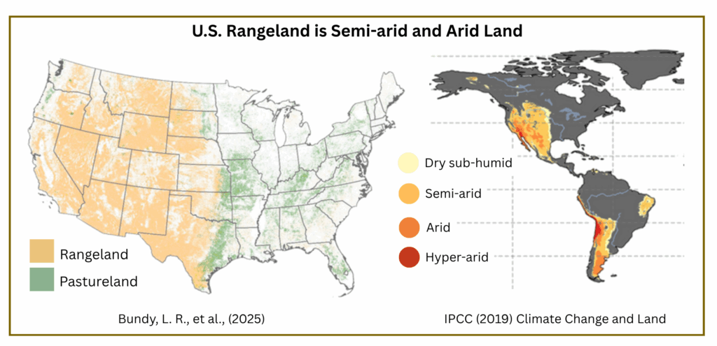
Conditions for both grazing and croplands continue to deteriorate.
![]() Grazing – In the U.S. grazing mostly occurs in arid or semi-arid regions.[1,2] These drylands are highly susceptible to degradation and risk desertification.[3,4] And in recent years, degradation due to grazing is increasing.[5] Conditions are predicted to worsen due to climate change and drought.[6,7]
Grazing – In the U.S. grazing mostly occurs in arid or semi-arid regions.[1,2] These drylands are highly susceptible to degradation and risk desertification.[3,4] And in recent years, degradation due to grazing is increasing.[5] Conditions are predicted to worsen due to climate change and drought.[6,7]
![]() Croplands – Soil loss and degradation continue at unsustainable levels.[8-10] Topsoil loss is endemic in monoculture production, especially for corn and soybeans.[11]
Croplands – Soil loss and degradation continue at unsustainable levels.[8-10] Topsoil loss is endemic in monoculture production, especially for corn and soybeans.[11]
![]()
Grazing map [Bundy, L. R., et al., (2025). United States pasture and rangeland conditions: 1995–2022. Agronomy Journal, 117(1), e21736, Figure 1, p. 3. ]
Drylands map [IPCC (2019) Climate Change and Land: an IPCC special report on climate change, desertification, land degradation, sustainable land management, food security, and greenhouse gas fluxes in terrestrial ecosystems (P.R. Shukla, et al., eds.), Technical Summary, Figure TS.6, p. 51.]
IPBES (2018): The IPBES assessment report on land degradation and restoration. Montanarella, L., et al., (eds.) Secretariat of the Intergovernmental Science-Policy Platform on Biodiversity and Ecosystem Services, p. 141. [“Over half of grazing lands occur in dryland environments that are highly susceptible to land degradation.”]
Huang, J., et al., (2020). Global desertification vulnerability to climate change and human activities. Land Degradation & Development, 31(11), 1380-1391, Figure 3, p. 4. [“The high level of desertification risk is mainly in the western part of the United States, the Sahel, central Asia, and northern China, where vegetation is sparse (Figure 2c) and the climate is dry (Figure 2b).” at p. 5]
See, Land Degradation & Grazing for information about the accelerating degradation of federal and private grazing lands
Steinfeld, H., et al., (2019). Overview paper: Livestock, Climate and Natural Resource Use, Kansas State Univ., p. 6. [“the effects of climate change on livestock… are expected to be most severe in arid and semi-arid grazing systems at low latitudes, where higher temperatures and lower rainfall is expected to reduce rangeland yields and increase degradation. Predicted changes in climate and weather are likely to result in more variable pasture productivity and quality, increased livestock heat stress, greater pest and weed effects, more frequent and longer droughts, more intense rainfall events, and greater risks of soil erosion.”]
Bundy, L. R., et al., (2025), p. 2. [“Therefore, the onset of drought and extreme rainfall events, in addition to warmer summers, land fragmentation, and invasive non-native species, will continue to have negative impacts on grazing systems across the United States.”]
USDA (2020) Summary Report: 2017 National Resources Inventory, NRCS and Center for Survey Statistics and Methodology, Iowa State University, p. 2-8. [More than 4.5 tons of soil lost per acre and 1.7 billion tons total were lost to erosion in 2017]
Thaler, E. A., et al., (2022). Rates of historical anthropogenic soil erosion in the midwestern United States. Earth’s Future, 10(3), e2021EF002396, p. 13. [“…our findings indicate that soil erosion rates in the Midwest are occurring at unsustainable levels and there is not a clear indication that the rates have declined since soil conservation practices and policies were implemented in the wake of the Dust Bowl of the 1930s.”]
Rosenberg, A. B., et. al., (2022) USDA Conservation Technical Assistance and Within-Field Resource Concerns, USDA ERS, EIB-234, p. 15. [In a survey of crop producers “growing wheat, soybeans, oats, or cotton—which collectively account for 43 percent of planted cropland in the United States… Respondents report that 49 percent of fields represented have at least one resource concern and 26 percent have multiple resource concerns.” Soil erosion is the most common concern.]
Thaler, E. A., et al., (2021). The extent of soil loss across the US Corn Belt. PNAS, 118(8), e1922375118, p. 2. [“…75% of the corn and 60% of the soybeans produced in the United States are grown in the Corn Belt… The Corn Belt currently has the highest soil erosion rates in the United States.”]