The USDA’s Economic Research Service (ERS) has provided “Major Uses of Land” reports since 1945. Their studies provide the most comprehensive accounting of all major uses of public and private land.[1,2]
The agency publishes a report approximately every 5 years based on several sources including the USDA’s Census of Agriculture. The most recent report was generated in September 2024 referring to a baseline year of 2017.[3]
Data files are also posted online, including supplementary information.[4] Some of the cropland figures are updated annually online.[5]
Winters-Michaud, C., et al., (2024) Major Uses of Land in the United States, 2017, USDA ERS Bulletin No. 275. See Preface, p. v. [We rely on this this report throughout these pages, adding other USDA information and our own calculations when appropriate.]
USDA ERS (updated 3/31/25) Major Land Uses – Documentation.
https://www.ers.usda.gov/data-products/major-land-uses/documentationWinters-Michaud, C., et al., (2024) [Note: Previous reports were typically generated 4-5 years after the baseline year, while the most recent report was generated 7 years after the baseline and refers to Census of Ag 2017 (and not the most recent Census of Ag 2022).
USDA ERS (2025) Major Land Uses.
https://www.ers.usda.gov/data-products/major-land-uses/USDA ERS (2025) Major Land Uses, See, Summary table 3: Total cropland used for crops.
The USDA estimates the total U.S. land area in 2017 at 2.26 billion acres.[1]
The USDA’s estimate of land area in the contiguous 48 states (excluding Alaska and Hawaii) is 1.89 billion acres.[1]
Winters-Michaud, C., et al., (2024) Major Uses of Land in the United States, 2017, USDA ERS Bulletin No. 275, Table 1, p. 5. [This report refers to the “contiguous 48 states,” or in the tables, simply “48 States.” We follow that protocol. We focus on information for the 48 states, since agricultural land is negligible in Alaska and Hawaii.]
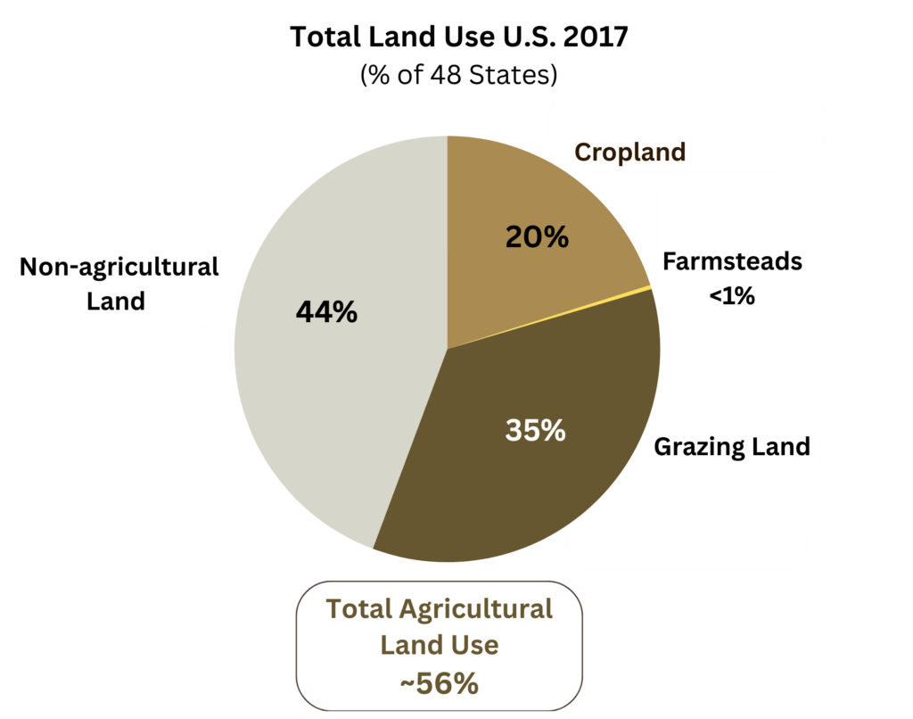
Agricultural land makes up ~56% of the land area of the contiguous 48 states.
In 2017, agricultural land accounted for 1.05 billion acres.[1,2]
Winters-Michaud, C., et al., (2024) Major Uses of Land in the United States, 2017, USDA ERS Bulletin No. 275, Table 1, p. 5. [1.054B acres / 1.891B = 55.7%. Agricultural land use in Alaska and Hawaii is negligible, at less than 0.1%. (~1.6M acres / 2.26B acres = 0.07%)]
Although Winters-Michaud reports agricultural land as 63% of the contiguous U.S. we use a lower figure. Of the 803 million acres used for grazing, 671 million are grazed as the “primary use,” (658M acres of pasture and rangelands and 13M acres of cropland pasture) while 132 million are “forest-use lands” that are “grazed to some extent.” We do not include this 132M acres in any of our calculations of agricultural lands or total land used for animal ag. This is consistent with our effort to be conservative in our calculations of the impacts of animal ag.
![]() Cropland = 377 million acres, or ~20% of 48 states.
Cropland = 377 million acres, or ~20% of 48 states. ![]() Grazing land = 671 million acres, or ~35%.
Grazing land = 671 million acres, or ~35%. ![]() Farmsteads and farm roads = 6 million acres, or less than 1%.[1,2]
Farmsteads and farm roads = 6 million acres, or less than 1%.[1,2]
Winters-Michaud, C., et al., (2024) Major Uses of Land in the United States, 2017, USDA ERS Bulletin No. 275 [Total = 1.054B acres / 1.891B acres = 55.7%] And see, https://docs.google.com/spreadsheets/d/1STqOzChHKrA7eC4XT4RIaZqzjJf-lydyeH8GVCLkwMw/edit?gid=0#gid=0
Note: The Major Uses of Land report classifies Cropland Pasture (13.4M acres) both as grazing land (Tables 1 and 8), and as cropland (Table 5). In the report’s primary listing (Table 1, p. 5.) it is included under grazing, since the actual use in 2017 was for grazing. We follow that protocol, while also noting that “…cropland pasture is considered to be in crop rotation or could be used for crops without improvements. Much of the cropland used for pasture is rotated between crop and pasture use, although the length of the rotation period varies across farms.”]
“Cropland” is considered by the USDA to be all land in crop rotation; it is made up of 5 components.[1,2]
![]() Cropland used for crops = 338 million acres (including 3 of the 5 components):
Cropland used for crops = 338 million acres (including 3 of the 5 components):
1. cropland harvested.
2. land on which crops failed.
3. cultivated summer fallow.
The sum of these 3 components is the amount of acreage devoted to crop production in a given year.[3]
![]() Idle cropland = 39 million acres – is land that is either diverted from crop production under government conservation programs or land “seeded to cover or soil-improvement crops,” such as buckwheat and clover. While idle cropland was not used for crop production in the baseline year, it often rotates into production in other years.[4]
Idle cropland = 39 million acres – is land that is either diverted from crop production under government conservation programs or land “seeded to cover or soil-improvement crops,” such as buckwheat and clover. While idle cropland was not used for crop production in the baseline year, it often rotates into production in other years.[4]
![]() Cropland pasture = 13 million acres – is “Grazed land on which no crops were harvested that year but is considered to be in long-term crop rotation and/or could have been cropped without additional improvement.”[5]
Cropland pasture = 13 million acres – is “Grazed land on which no crops were harvested that year but is considered to be in long-term crop rotation and/or could have been cropped without additional improvement.”[5]
Winters-Michaud, C., et al., (2024) Major Uses of Land in the United States, 2017, USDA ERS Bulletin No. 275. p. 14-18 and Appendix A: Glossary, pp. 60-63.
USDA ERS (updated 3/31/25) Major Land Uses – Documentation.
https://www.ers.usda.gov/data-products/major-land-uses/documentationWinters-Michaud, C., et al., (2024), p. 14-15. [“The sum of three of these components, cropland harvested, crop failure, and cultivated summer fallow, constitutes the cropland used for crops category or the acreage devoted to crop production in a given year.”]
Winters-Michaud, C., et al., (2024), p. 15. [“The other two components, cropland pasture and idle cropland, are not directly used for crop production in a given year but may rotate into production in other years.”]
Note: The Major Uses of Land report classifies Cropland Pasture (13.4M acres) both as grazing land (Tables 1 and 8), and as cropland (Table 5). In the primary listing (Table 1, p. 5.) it is included under grazing, since the actual use in 2017 was for grazing. We generally follow that protocol, while also noting that it is listed under “cropland” in parts of the report.
The USDA breaks down “land used for grazing” into 3 components.[1,2]
![]() Grassland pasture and range = 658 million acres – is primarily used for livestock grazing.[3]
Grassland pasture and range = 658 million acres – is primarily used for livestock grazing.[3]
![]() Grazed forest-use = 132 million acres – includes open forest, land reverting to forest, and other forested areas with grass or other forage growth that are “grazed to some extent.”[4]
Grazed forest-use = 132 million acres – includes open forest, land reverting to forest, and other forested areas with grass or other forage growth that are “grazed to some extent.”[4]
![]() Cropland pasture = 13 million acres – is “grazed land on which no crops were harvested this year but is considered to be in long-term crop rotation and/or could have been cropped without additional improvement.”[5]
Cropland pasture = 13 million acres – is “grazed land on which no crops were harvested this year but is considered to be in long-term crop rotation and/or could have been cropped without additional improvement.”[5]
Winters-Michaud, C., et al., (2024) Major Uses of Land in the United States, 2017, USDA ERS Bulletin No. 275, Table 1, p. 5 and pp.29-30. [Again, we use figures for 48 states. Alaska and Hawaii use about 1.5 million acres for grazing, or about 0.2% of total U.S. grazing land.]
USDA ERS (updated 3/31/25) Major Land Uses – Documentation: Grassland pasture and range, Forest-use land grazed, Cropland used only for pasture.
Winters-Michaud, C., et al., (2024), Table 1, p. 5. [“Livestock grazing was the primary use of an estimated 659 million acres of grassland pasture and range in 2017…” The total for 48 states was 658M acres. at p. 6.]
Winters-Michaud, C., et al., (2024), p. 30. [“In 2017, the 132 million acres of grazed forestland in the United States included acreage in open forest, land reverting to forest, and other forested areas with grass or other forage growth that were grazed to some extent.” We do not include this figure in our calculations of total agricultural land, or total land for animal ag since grazing is not the primary use.]
Winters-Michaud, C., et al., (2024), p. 16 and Glossary, p. 60.
Of the ~800 million acres of total grazing land, non-federal grazing land was estimated at ~585 million acres.[1,2] Federal grazing land was ~215 million acres.[3-5]
Some portion of both categories was forest-use land grazed to some extent, though not the primary use.
These figures for federal and non-federal grazing lands are not calculated in the Major Uses of Land report. Here we use an approximate figure of 800 million acres for total grazing land (not the more precise 803M from Major Uses of Land. The figure of 800 million acres aligns closely with data from the following reports. We include in this answer the 132 million acres that are “forest-use lands” where grazing is not the primary use. We do not include this quantity in total agricultural lands nor total land use for animal ag.
USDA National Resources Conservation Service RCA Data Viewer. Land Use Trends, Query: National / Grazing Land. [585M acres includes forested, pastureland and rangeland. [Note: In 2017, the NRCS is used by Major Land Uses as its source for non-federal land. The non-federal lands include privately owned lands, tribal and trust lands, and lands controlled by states and local governments.]
https://publicdashboards.dl.usda.gov/t/FPAC_PUB/views/RCADVLandUsebyStateNRI20171/StateLandUseTrend?%Congressional Research Service (2019) Grazing Fees: Overview and Issues, RS21232, p. 1. [“Of total BLM land, 154.1 million acres were available for livestock grazing in FY2017. The acreage used for grazing during 2017 was 138.7 million acres.” “Of total FS land, more than 93 million acres were available for grazing in FY2017, with 74 million used for livestock grazing.”]
Note: An additional 4 million acres are managed for grazing by other federal agencies, including the National Park Service. Assuming that half were actively grazed brings the total to ~215M acres. See, U.S. GAO (2005) Livestock Grazing, Federal Expenditures and Receipts Vary, Depending on the Agency and the Purpose of the Fee Charged, GAO-05-869, p. 16-17.
See, Grazing on Federal Lands [question: How many federal acres are actively grazed?]